Carbonic acid is formed as a result of the combination of soluble rocks such as pothole , underground limestone with carbon dioxide over time, and this carbonic acid dissolves the soils with excess limestone over time, causing the formation of large cavities and caves underground. Deep pits are formed by the collapse of the soil on the cave that is formed later.
These cavities, which have differences in depth and width, are called sinkholes. In other words, it is a karstic landform formed by the collapse of the ceilings of the formed voids. There are many depressions in regions where soluble rocks are diverse. The sinkholes are mostly formed on alluvial soils.
How is a sinkhole formed?
Many sinkholes have two forms of formation. In the first, the rocks that can melt under the soil dissolve with the water that seeps from the soil and goes underground, and the spaces in the rocks expand and these spaces are filled with soil.
As the groundwater continues to dissolve the rock, it creates cavities that are not very deep. As these shallow cavities come together, larger, irregular closed depressions form a union. The second one is formed as a steep-sided crater as a result of the collapse of a cave ceiling.
Rock movements occur as a result of the decrease and shrinkage of underground waters as a result of use due to global warming and agriculture. Sinkholes occur when the surface areas above the underground caves approaching the earth cannot carry the load and collapse.
For the formation of sinkholes, conditions other than karst areas are required. There should be two different basins of groundwater levels. Fault lines also have an effect on the formation of sinkholes. For example, the fault located in the southwest of Tuz Gölü is the cause of the formation of Dikmen and Koca sinkholes.
Pothole Types Can Be Classified as:
- Dissolution Pitches
- Buried Sinks
- Cover Rock Pitches
- Collapsed Sinkholes
- Destruction Sinkholes
- Flat Sinkholes
A few variables are taken into consideration when classifying the sinkholes. These variables are: The formation process of the pothole, the formation rate of the pothole and the rock type. In the formation of the pothole, it is divided into three types as melting, settling and collapse.
1) Melting: Surface waters passing through the thin surface layer dissolves with these infiltrating waters, and the soluble rocks below dissolve, and the cavities in the limestone expand and slowly fill the cavities with soil. With the dissolution, sinkholes occur on the surface due to the melting.
2) Settlement: Cohesionless soils such as sand, especially in areas with a thick surface layer, are filled with sandy structures on them as the limestones dissolve with groundwater and the water level recedes. As the sandy structure fills the voids, sinkholes with low slope and shallow depth are formed.
3) Collapse: Particularly in areas with thick clayey surface layers, underground cavities expand, the clayey structure crumbles and collapses, and finally, the collapse of the clayey structure that serves as the roof (ceiling) creates steep-sided collapse type sinkholes.
Sinkhole in our country
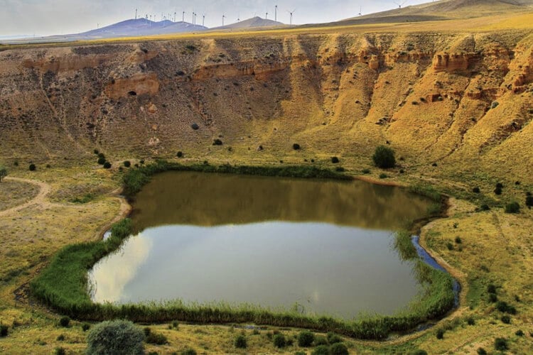
There are more than twenty-five sinkholes in the Konya Basin, which contains one third of the groundwater in Turkey. In Turkey, the most sinkholes are seen in the Konya Closed Basin. The experts of the subject stated that the product grown by using plenty of water, such as the sugar beet in the region, is one of the factors affecting the formation of the sinkhole recently.
In fact, the formation of the sinkhole is a rare natural phenomenon that occurs naturally due to the karstic structure of the soil, while the use of underground waters by drilling causes the formation of the sinkhole to be used more frequently. The most common region in Konya is Karapınar.
There are sinkholes with a length of 130 meters and a width of 9 meters in the region. According to researchers, up to fifty sinkholes can form within a year. More than a thousand sinkholes have been identified in Konya. 600-650 of them are located in Karapınar. Three or four years ago, this number was only between 180-200. With the studies carried out in 2020, it has been determined that this number has increased to 600.
Sinkholes in Turkey
Karst areas cover a large area in Turkey. Most of the karst areas are limestone lands. The Obruk Plateau, located in the southern part of Tuz Gölü, is home to many different sinkholes. The Kızören, Çıralı, Hamam, Meyil, Gökhöyük and Kangallı potholes are examples of the potholes on this plateau. There are also sinkholes in our provinces such as Mersin, Kırşehir, Kastamonu and Antalya. Mucur sinkhole, Heaven and Hell sinkhole are some of them.
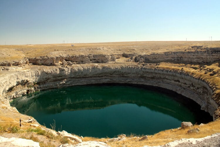
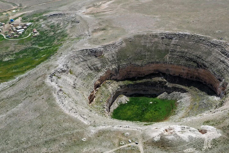
Kizören Sinkhole
The Kızören pothole is one of the most famous, with a width of 228 meters and a depth of 171 meters. It is a karst-formed pothole located within the borders of Karatay district of Konya. 145 meters are filled with water. It is the biggest sinkhole of our country. The water surface, located 20 meters below, is getting lower every year due to excessive use of groundwater. A level difference of 5 meters is observed throughout the year. In 2005, the lake and its surroundings were declared a Ramsar area. No living species was found in the lake.
Meyil Obruk Lake
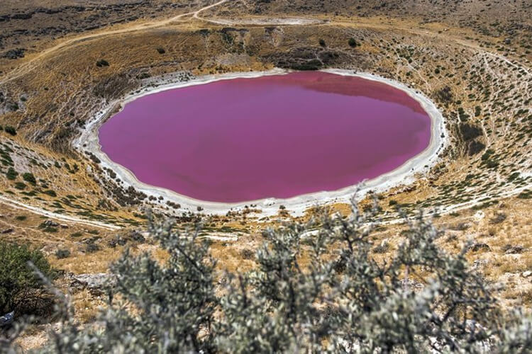
Obruk Meyil Obruk Lake, which draws attention with its visual beauty. It is located in the Karapınar district of Konya. Its length is 387 meters, and its width is 350 meters. The total depth of the pothole is 104 meters, the depth of the lake is 40 meters. The water level has been decreasing in recent years.
With the increase in temperatures and the decrease in the water level, the lake turns pink due to bacteria in the water of the artemia salina species. As a result of bacterial explosions, coloration occurs in the water. Since its water is salty, not many creatures live in it. There are bacteria that can live mostly in salt water.
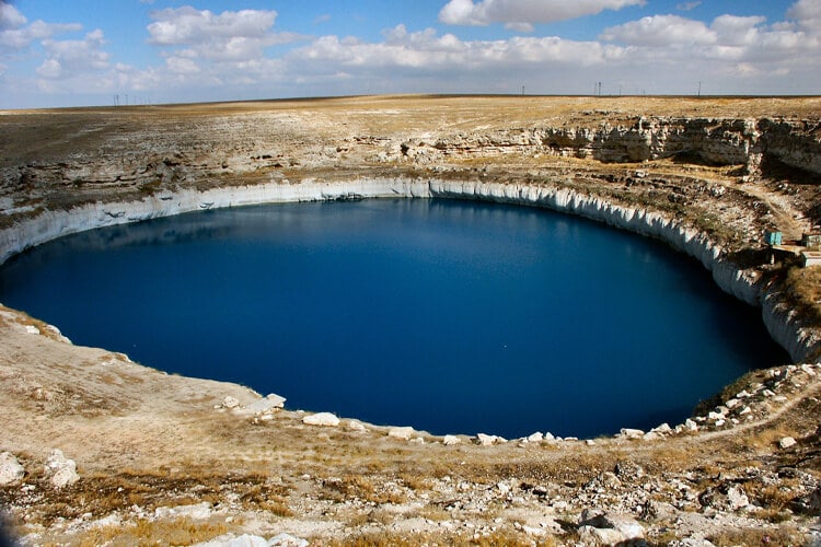
Mucur Pitcher
It is a sinkhole located within the borders of Mucur district of Kırşehir province. It has a depth of 50 meters and a width of 400-450 meters. Although the lake waters decrease in summer, they do not dry out. Vitality was ensured by throwing mirror carp fry into the lake.
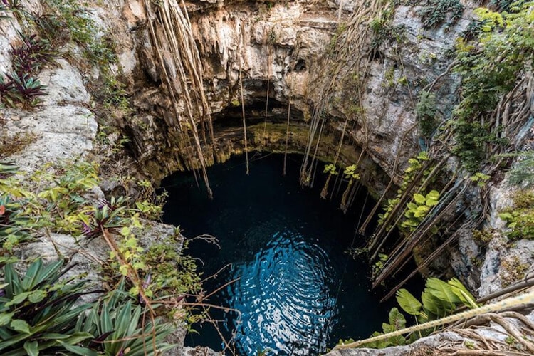
Heaven and Hell Pitches
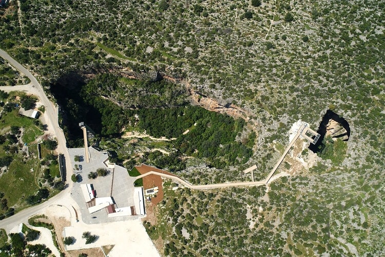
The sinkhole, located near Silifke-Narlıkuyu, was formed by natural means. They are very deep caves. They are sinkholes formed as a result of the collapse of the ceiling due to chemical erosion of the underground stream.
Heaven Pitcher
It is in the shape of an ellipse. The opening of the mouth is 250 x 110 meters. There is a large cave entrance with a length of 200 meters and the deepest point of 135 meters on the south side of the base of the formation, which has a depth of 70 meters.
A large stone stairway with 450 steps is descended into the Paradise pothole. At the entrance of the cave is the Virgin Mary Church. It is known from the four-line inscription at the entrance that the church was built by a pious person named Paulus for the Virgin Mary.
Hell Pitcher
It is located 75 m north of Cennet pothole. Mouth diameter is 75×50. It is not possible to descend into this depression since the outer edges of the pothole have a concave formation. It has a depth of 128 meters. According to Greek mythology, Zeus imprisoned Typhon, the hundred-headed fire-breathing dragon, in the Hell’s pit for a while after he defeated it in battle. The temple was converted into a church during the Christian era.
The Deepest Sink in the World: Xiaozhai Tiankeng
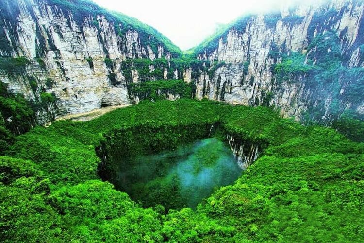
It is the world’s largest sinkhole. This sinkhole is located in China. It is 626 meters long, 516 meters wide and 511-662 meters deep. It was formed by a mighty river flowing underground. There are 1285 plant species and many rare animals in the pit. In order to facilitate tourism in the region, 2 thousand 800 steps were built.
Prevention and Dangers of Pitfall Formation
Researchers state that in order to reduce the formed sinkholes, risk maps should be created and graded by conducting geophysical surveys and geological studies. They say that the use of underground water should be controlled and that illegal water wells should be identified and closed.
In industry, groundwater withdrawal should be reduced by treating wastewater and reusing it in the factory. If there are residential, industrial and transportation facilities in areas where pothole formation may occur, controls should be provided and if dangerous, they should be moved from that area. In case of sudden collapses, the safety of life and property is in danger. With the formation of the sinkhole, there is also a loss and danger in agricultural areas.
This post is also available in: