Earthquake, as one of the most devastating disasters on the planet, has cost the lives of millions of people from past to present. Each community tried to explain the earthquake according to their own beliefs and made up various legends. So what is an earthquake? How does it occur? What are the earthquake zones in the world and in Turkey? What are the ways to protect from earthquake? How to prepare an emergency bag? All questions answered in this article. So let’s start!
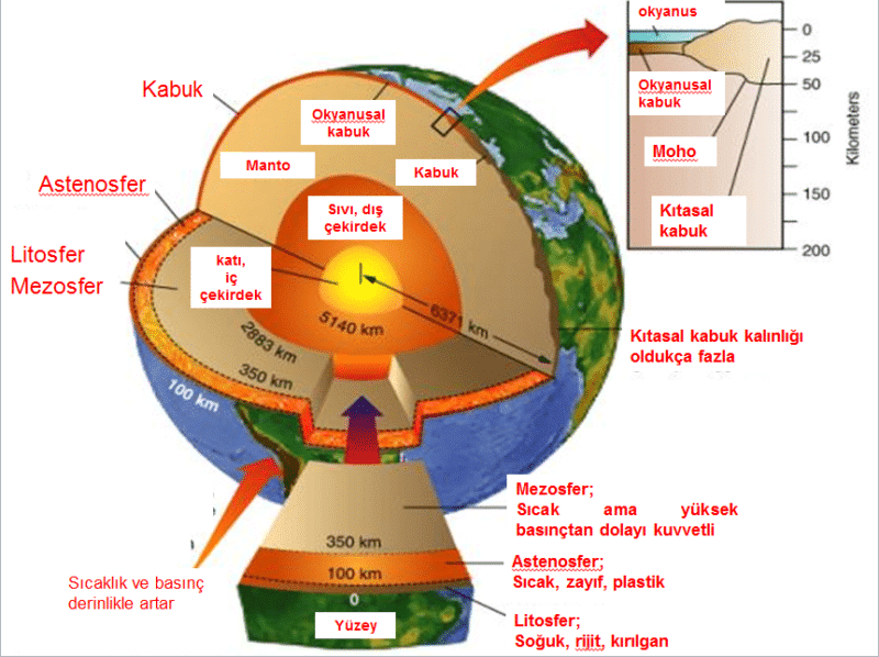
The planet we live in is a huge sphere with a radius of 6370 km.

When we consider the layers of the Earth, from the outermost to the inside, the first layer is the Lithosphere (solid), the second layer is the Asthenosphere (fluid, viscous), the third layer is the Mantle (semi-viscous, semi-fluid) and the fourth layer, the core (solid), in the center. The thickness of the lithosphere ranges from 70 to 80 km. We live on the Lithosphere. The temperature of the Asthenosphere layer just below is 1500-200 C and has the consistency of gum.
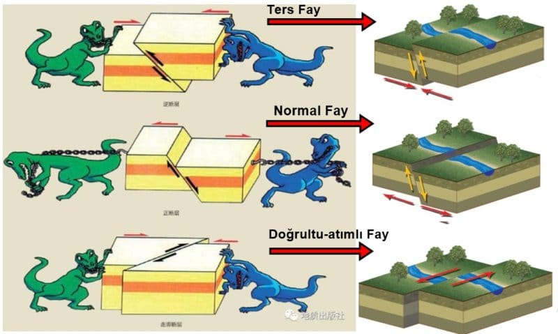
Sudden movements occur on faults under the influence of tectonic forces.
The lithosphere is in motion above the Asthenosphere layer. The vibrations released as a result of these movements create earthquakes that cause damage by moving through the lithosphere. Why and how does the earthquake, which is known as earthquake among the people and also known as seismic or ground shaking, occur? The effect of unexpectedly emerging energy in the earth’s crust, spreading in waves and shaking the regions they pass through, is called an earthquake. Earthquakes are the most devastating and unpredictable on the planet, with several million earthquakes thought to shake our world each year. Most of these ground shaking are not felt.
When the earth’s crust is ruptured or ruptured, a great seismic force is released.
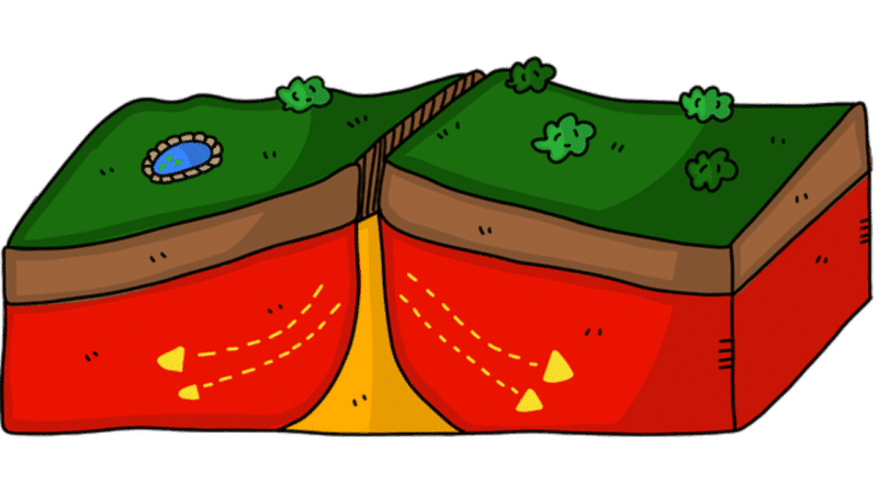
There is at least one major shaking in any part of the world during the year. Most earthquakes are caused by the movement of large plates in the earth’s crust called tectonic plates. When these plates begin to stretch mutually, a great pressure is created. This released energy is defined as the magnitude of the earthquake. The greater the size, the greater the energy released. The energy released in earthquakes of 8 and greater is equal to the power of 1 million tons of TNT or 67 thousand Hiroshima bombs.
What are the types of earthquakes?
Types of earthquakes vary according to the causes of their occurrence. Ground shaking caused by the movements of the plates are known as tectonic earthquakes. Tectonic earthquakes usually occur at plate boundaries. Most of the earthquakes that occur on the earth, such as 90%, fall into this group. The majority of earthquakes in our country are tectonic earthquakes. Volcanic earthquakes are the second type of earthquakes. Volcanic earthquakes occur as a result of the eruption of volcanoes. It is known that these earthquakes occur as a result of the explosion of gases formed by chemical and physical events during the escape of molten material from the depths of the earth to the earth.
How is the intensity and magnitude of an earthquake measured?
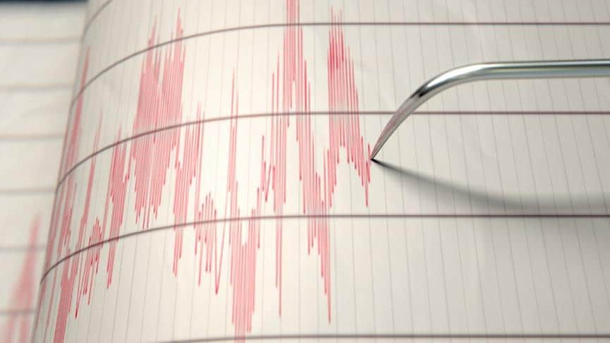
During the formation of the earthquake, three main waves emerge. The wave that emerges first is called the primary wave. These waves travel very quickly and continue by creating small tremors. The primary wave can hardly be felt by humans. These waves are mostly felt by animals. The real big and destructive wave, namely surface waves, occurs just a few seconds after this wave. The location of the shaking is also determined by the movement of the earthquake waves that occur at different speeds from each other. By calculating the time difference between the primary and surface waves reaching the earthquake stations, it is determined how far away the earthquake is.
The intensity of the earthquake and the magnitude of the earthquake are different concepts.
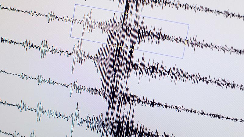
Numbers like 5.7, which we learned after the earthquake news, show the magnitude of the earthquake, not its intensity. The intensity of the earthquake is indicated by numbers between 1 and 12. The severity of the earthquake can be said by looking at the damage left on the earth. Two earthquakes of the same magnitude may have different intensities in different cities. While people living in a place with an earthquake intensity of 2 feel this earthquake very slightly, in an earthquake of magnitude 7, the furniture inside the house topples, it becomes difficult to stand still and moderate damage occurs to the buildings. The magnitude of the earthquake is determined by looking at the length of the line formed by the seismographs of the earthquake waves. Long lines mean that the earthquake is big. Unlike intensity, an earthquake has only one magnitude.
What are the 3 major earthquake zones?
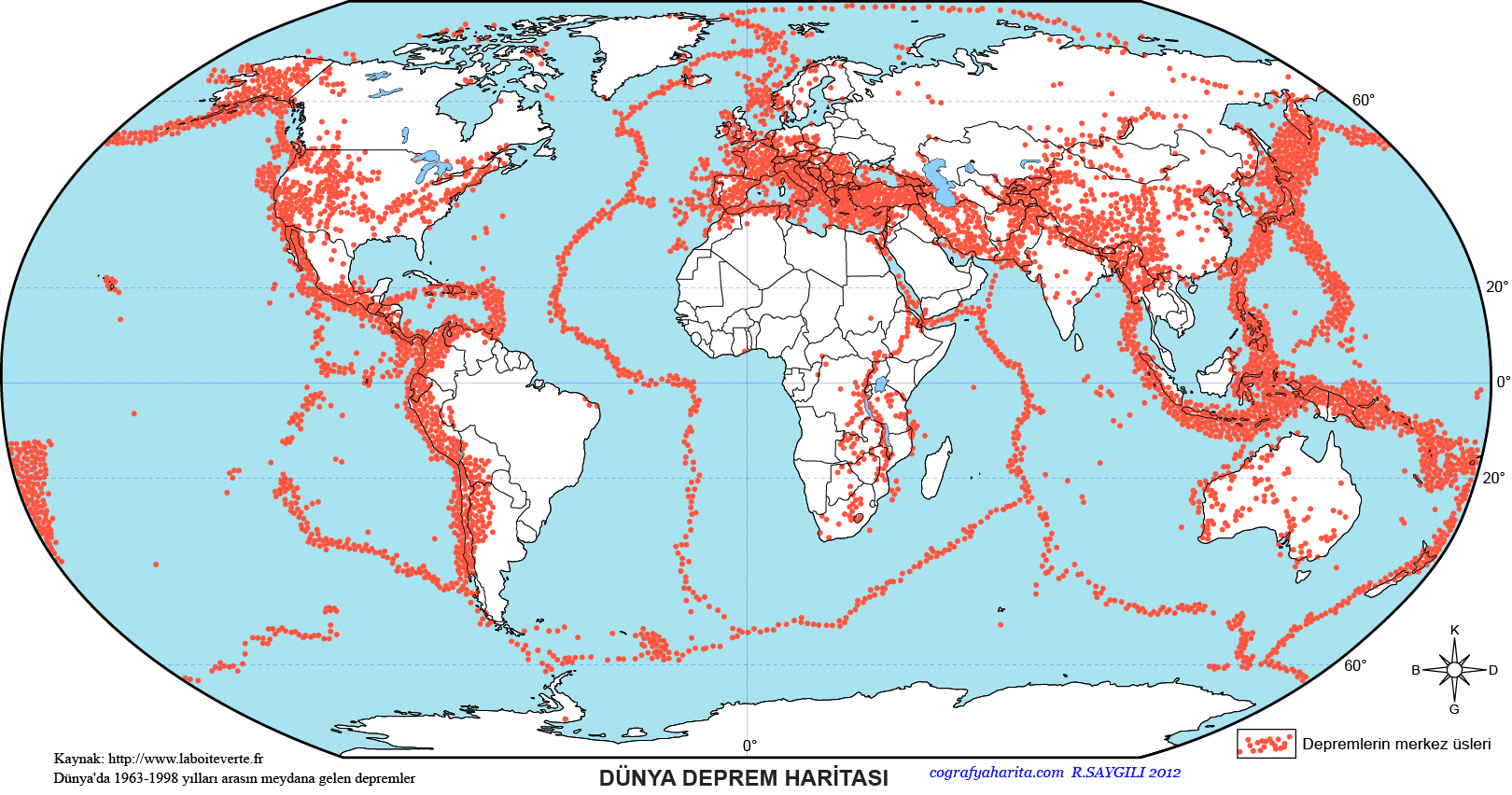
Although ground shaking can occur in every region of the world, almost all of these shakes occur in 3 regions. The “Mid-Atlantic” ridge that runs through the middle of the Atlantic Ocean. The Alpine belt, which provides the formation of geographical regions such as the Mediterranean, Anatolia and the Himalayan mountains and passes over Turkey. The Pacific seismic belt or otherwise known as the Ring of Fire, which caused so many earthquakes in Japan. When we consider all the earthquakes that occur on the planet, and when we consider that 80% of these earthquakes occur in the pacific earthquake belt called the ring of fire, we can understand why it was named the Ring of Fire. The biggest earthquake, the 1960 Chile earthquake, also occurred in the Ring of Fire in the same way.
Where and when did the biggest earthquake in the world occur?
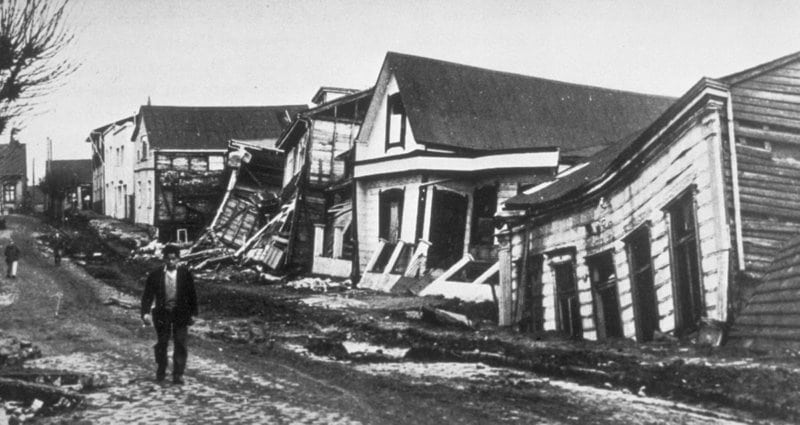
May 22, 1960 Chile earthquake. It was recorded as the strongest earthquake that could be measured of all time. Also known as the Valdivia Earthquake. The earthquake had a magnitude of 9.5 and lasted for 10 minutes. The waves of the earthquake affected an area of 400 thousand square kilometers. It was such a big earthquake that although there was the Pacific Ocean in between, the Asian Continent, including the USA, Mexico and Australia, were affected by this earthquake. The city was razed to the ground, the power lines were completely cut off, and despite the incessant rains, problems in finding clean water arose in the city. According to the reports kept, 3000 people died as a result of the earthquake. The effects of this terrible earthquake that occurred in Valdivia affected not only the period in which it was lived, but also the future. According to the information conveyed by experts, 20. The Chile earthquake triggered 25% of the earthquakes that occurred in the 20th century.
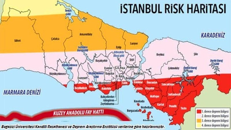
Turkey’s Three Most Dangerous Fault Lines: North, East and West Fault Lines
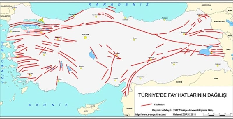
It is known by almost everyone that our country is an earthquake country. The African and Arabian plates located in the south of Turkey are pushing our country towards the north and west. The region we call Anatolia in the energy released by pushing could not withstand this tension and broke. With this fracture, Anatolia was divided into two parts and a surface that was kilometers long underground formed. This fracture formed in the northern part of Anatolia is called the North Anatolian Fault Line.
With the breaking of the Anatolian plate, the Arabian plate continued to push. As a result, the lower part of Anatolia continued to slide towards the west, rubbing against the upper part, every year. While the friction situation continued, at certain points, these parts got stuck on the protrusions that prevented the friction. This compression prevented the plate from moving westward. However, the compression does not mean that the piece of Anatolia that remains under is not continued to be pushed. Since the pushing movement continued and the plate could not move due to compression, this great energy that emerged began to accumulate in the protrusions formed on the fault line.
This gigantic energy, which continued to accumulate for years, caused the eruption in Erzincan to break in 1939 and an earthquake with a magnitude of 7.9 emerged. After this terrible earthquake, the energy accumulated on the fault line passed to the Tokat region, which is located at the next point, 3 years later. In 1942, that section also broke, causing an earthquake of 7 magnitude. This energy transfer continued at every continuing point of the fault line, and earthquakes continued to occur in the next section throughout the years. The last earthquake that occurred on the fault line occurred in 1999 in the Gölcük district of İzmit.
The Biggest Earthquake in Turkey: Erzincan Earthquake
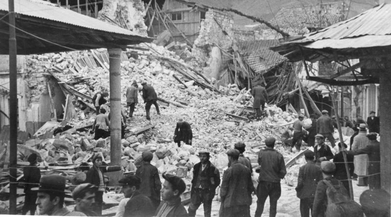
Located in the 1st degree earthquake zone, Erzincan is located on the North Anatolian Fault Line. It is the most severe earthquake recorded in Turkey. More than 33 thousand people lost their lives in the Erzincan earthquake of 26-27 December 1939. The earthquake that occurred at 02:00 at night lasted for exactly 52 seconds and caused the destruction of 116,720 buildings, including the government office, army inspectorate, army house, post office and the city’s strongest buildings. The earthquake, which completely destroyed Erzincan, was also felt and its effects were seen in surrounding cities such as Amasya, Tokat, Sivas, Kırşehir, Ankara, Kayseri, Samsun, Ordu.
In addition to the majority of adobe and wooden houses, the coldness of minus 30 degrees turned the dimensions of the disaster into a disaster that will never be forgotten. Despite the severity of the earthquake, the only building that survived was the Erzincan Train Station building. The station building was evaluated and used as a hospital. All aid to the region was made by train. The prisoners in the prisons were released and they joined the search and rescue efforts with shovels in their hands. After the earthquake, non-governmental organizations, especially the Turkish Grand National Assembly, carried out activities for the earthquake victims. The resettlement of the earthquake victims and the reconstruction and construction process of the city to be rebuilt in Erzincan were accelerated as much as possible.
Why is a big earthquake expected for Istanbul?
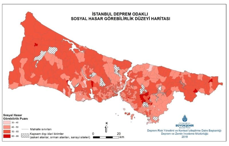
The following part of the North Anatolian fault line after Izmit passes through the Sea of Marmara. When the 1999 Izmit Earthquake took place, the energy remaining on the fault line was transferred to the next section, the Marmara. In the Marmara region, it can be determined that energy is accumulated in the region in the underground measurements made by geologists.
It is a much more difficult situation to detect where the protrusion that prevents the pushing movement is located. Even if the protrusion that prevents the friction movement can be detected, it is not possible to measure how much force this protrusion can withstand with current technology. Although it is known where it will happen, there is no clear information about when and how big the earthquake will be.
When will the Istanbul Earthquake take place?
For the big Istanbul earthquake that is expected to take place, geoscientists researching the floor of the Marmara Sea estimate that the realization of the big earthquake will occur between 60% and 70% by 2030. Even if this is just a guess, it unfortunately does not change the fact that the Istanbul earthquake can happen at any time.
According to the records kept during the Ottoman Period, it is said that a major earthquake occurs in the Sea of Marmara approximately once in 250 years. When all these data are considered, we can understand that there is not much time left for the Marmara earthquake to occur. Unfortunately, it is impossible to prevent the earthquake that will take place in the Marmara Sea.
Ancient Beliefs About Earthquakes: Elephants, Turtles…

Since ancient times, earthquakes have been a fact of the world. They expressed and explained the earthquake with different beliefs in different parts of the world. Even today, some of these superstitions are believed by certain people. According to these superstitions, which are far from science, the causes of earthquakes are gods, animals and creatures. People in India think that earthquakes are held by 4 elephants standing on a turtle, and the turtle is trying to balance on a cobra. According to this belief of the Indians, when any of the animals move, the earth begins to shake.
According to Mozambican belief, the earth is actually a living creature, not an inanimate one.
Even their problems are the same as ours. Sometimes if the creature trembles and gets cold, we feel it as an earthquake. According to the Siberian belief, the world stands on a giant sledge and the person driving this sled is God. A few dogs with fleas are pulling this sled used by the god Tuli. When dogs stop scratching, the world begins to shake. According to the belief in Mexico, a monster named El Diablo is carving great rifts on the earth, and these rifts are now fault lines. El Diablo and his evil friends use these giant rifts to stir up the earth, causing an earthquake.
According to the belief in Assam, there are people underground and they shake the ground to see if there are people on earth. When they hear the voices of the people on earth and understand what they are going through, they stop this shaking. According to the belief in Belgium, when God thinks that people are very sinful, he sends an angry angel to the world to change the air on earth. The resulting storms also produce a musical tone that is felt as a series of shocks.
How to prepare an emergency bag?

The aid kit is a life saver where emergency needs can be met until the first aid team reaches the victims after a natural disaster. The emergency kit should be prepared in advance and kept in an easy-to-reach place. Food and beverages in your emergency bag should be checked regularly and attention should be paid to their expiration dates.
What Should Be Included in the Disaster Bag?
• Sufficient amount of food and water
• Sleeping bag or a blanket that can protect you from the cold
• Clothes and raincoat
• Hygiene products
• Medicines you use regularly
• First aid products
• Tent
• Whistle, paper, pen
• Your important documents
• Radio, battery, flashlight, pocketknife
This post is also available in:


